Atlanten
Die Liste enthält 8 Einträge. Suchergebnisse löschen und Gesamtbestand anzeigen.
| Abbildung |
Beschreibung Stichwort, Autor, Titel, Buchbeschreibung |
Preis EUR |
|
|---|---|---|---|
| Atlas razvitija chozjajstva i kul’tury SSSR. Moskau, Glavn. Upravl. Geod. i Kartogr., 1967. 4°. 5 S., IX, 172 pages. Original clothbound, with dustjacket. The dustjacket dusty. | 120,-- |  |
|
| Atlas zemletrjasenij v SSSR. Rezul’taty nabljudenij seti sejsmic. stancij SSSR 1911-1957gg. Moskau, Izd. Akad. Nauk, 1962. 4°. 336 pages, 1 leave. Original Leinen. Cloth bound. Slighty stained and a bit dusty. | 65,-- | |
|
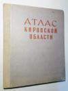 |
Bushmelev, G.A. (editor). Atlas Kirovskoj oblasti. Moskva, GUGIK pri sovete ministrov SSSR, 1968, Quart, 38 pages. (illustrated). Halbleinen. Corners a bit worn. otherwise good. | 38,-- | |
| Mashovets, V.I. (editor). Atlas Leningradskoj Oblasti. Moskva, GUGIK pri sovete ministrov SSSR, 1967, Quart, 82 pages. (illustrated). Original clothbound. | 38,-- | |
|
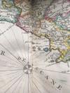 |
Sanson, Nicolas. Atlas Portatif et Nouveau du Voyageur pour l’Italie, avec la Description Geographique & une Table pour trouver facilement les Villes, & c. Amsterdam, Mortier, about 1700. Octav. 56 pages; 16 pages index. With 12 maps. (10 detailled maps and 2 overview maps), all with contemporary coloured frontier lines and an engraved mileage scale. Contemporary marbled cardboard. A bit waterstained. The spine has been restored professionally. Private stamp on title, otherwise fine and complete. | 580,-- | |
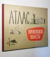 |
Smirnov, N.N. (editor). Atlas Voronezhskoj oblasti. Moskva, GUGIK pri sovete ministrov SSSR, 1968, Quart, 32 pages. (illustrated). Halbleinen. The corners of the cover are a bit wrinkled. | 39,-- | |
| Tadschikistan – Atlas Tadzikskoj Sovetskoj Socialisticeskoj Respubliki. Duschanbe und Moskau, Glavnoe Upr. Geodezii i Kartogr., 1968. Folio. 4 leaves, 200 pages. With several colourful maps. Original-Leinen, cloth bound. Good condition. | 148,-- | |
|
| Zmuda, Krolikowski (editors). Atlas Województwa Katowickiego. Warszawa, Panstwowe Przedsiebiorstwo Wydawnictw Kartograficznych, 1971, Quart, 15 pages, 1 n. n. page, 48 plates. Leinen. The top part of the book cover is slightly worn. 36 plates are not glued with the binding. | 24,-- | |
|
|
Einträge 1–8 von 8
Zurück · Vor
|
|||
| Seite: 1 |